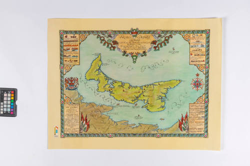
MAP
Date1964
Geography
Prince Edward Island
DimensionsOther: 74.5 x 57 cm (29 5/16 x 22 7/16 in.)
Object numberHF.11.3.11-12
DescriptionTwo Prince Edward Island Centennial map, created by Peter R. Furse and printed in 1964 by MacLean-Hunter Publishing Company Limited. The border features a repeating pattern of fish and pink lady slippers flowers with a coat of arms for the province of Prince Edward Island at the top center. Below the crest is text surrounded by sea creatures, the text says: "Prince Edward Island To which the name Ile Saint Jean was first given by Champlain in 1603 The name was changed in 1798 in honor of H.R.H. Prince Edward, Duke of Kent, Commander in Chief British North America." Within the border, in each corner is a rectangle which features historical facts about the territory and a legend. At the center of the map is Prince Edward Island with symbols marking locations of historical significance. Narrative
These maps were created by Peter R. Furse, a New Brunswick artist well-know for his pictorial maps. They were released in 1964 to mark the centennial anniversary of the Charlottetown Conference, when delegates from across what was then the British North American colonies met in Charlottetown to discuss unifying.
A limited run of 300 hand coloured lithograph maps were released of these souvenirs as well as printed versions which were sold in MacLean's Magazine for a price of $1.69.
Collections